|


BOSPHORUS (ISTANBUL) STRAIT:
Northwestern Turkey is divided by a complex waterway that connects the Black Sea to the Sea of Marmara and the
Aegean Sea. The channel passing between the Black Sea and the Sea of Marmara is named the Istanbul Bogazi, more
commonly called the Bosporus. Istanbul is positioned at the south end of the Bosporus. The Sea of Marmara is connected
to the Aegean Sea by a channel called the Canakkale Bogazi, also known as the Dardanelles.
The Turkish Straits, comprising the Strait of Canakkale, the Strait of Istanbul and the Sea of Marmara and, are
unique in many respects. The very narrow and winding shape of the strait is more a kin to that of the river. It
is an established fact that the Turkish Straits are one of the most hazardous, crowded, difficult and potentially
dangerous, waterways in the world for marines. All the dangers and obstacles characteristic of narrow waterways
are present and acute in this critical sea lane.
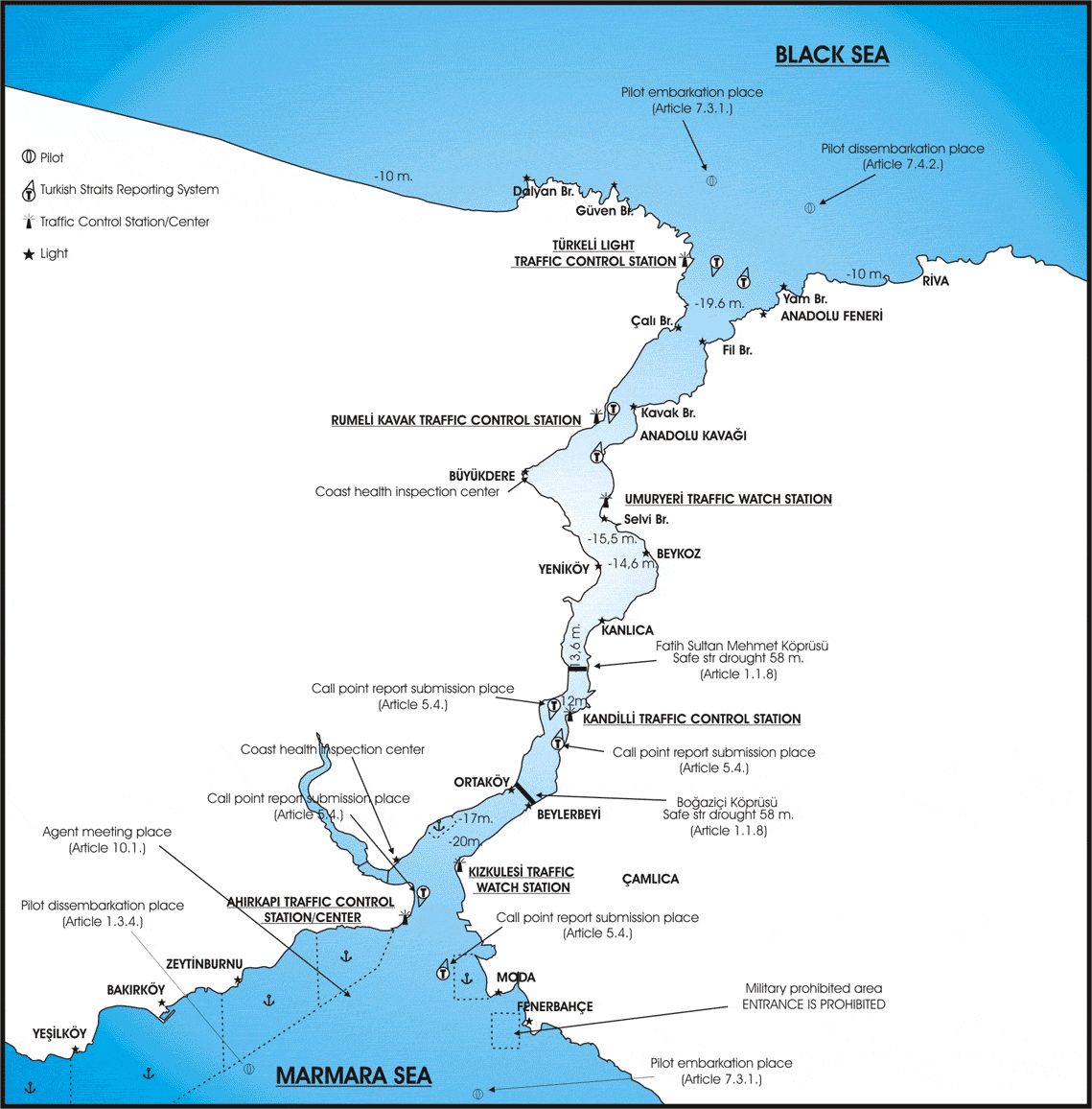
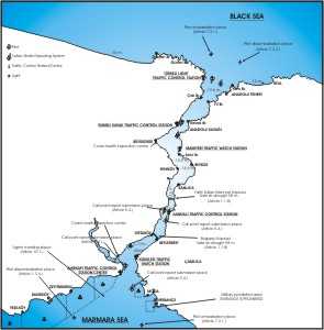
The Strait of Istanbul is approximately 16.74 nautical miles long, with an average width of 0.81 nautical miles.
It is only 0.378 nautical miles wide at its narrowest. The Straits of Istanbul takes several sharp turns. The ships
are bound alter course at least 12 times at these bends. At the narrowest point, Kandilli (700 m), a 45 degree
course alteration is required. The current can reach 7-8 knots at this point. At Yenikoy, the necessary course
alteration is 80 degrees.
At the above mentioned turns (Kandilli and Yenikoy) where significant course alterations have to be made, the rear
and forward sights are totally blocked prior to and during the course alteration. The ships approaching from the
opposite direction cannot be seen round these bends.
There is also very heavy ferry traffic in the Strait of Istanbul, which crosses between European and Asiatic sides
of the city.
There are two suspension-bridges spanning the Bosphorus which connects Europe and Asia. Istanbul - Bosphorus suspension
bridges 3 miles within the Strait connects Europe and Asia. It is 1074 m long between the legs and has a vertical
clearance of 64 m over a width of 400 m decreasing to 58 m at each end.
Click for enlarge picture
VESSEL TRAFFIC SEPARATION Traffic Separation Schemes (TSS)
The boundaries of the Traffic Separation Schemes which shall apply in the Straits and Marmara Region are delimited.
All maritime traffic must stay to the starboard side of the channel.
In the North, by the North border of the area joining the following points:
Lat. 41 deg. 16' N., Long. 028 deg. 55' E
Lat. 41 deg. 21' N., Long. 028 deg. 55' E
Lat. 41 deg. 21' N., Long. 029 deg. 16' E
Lat. 41 deg. 14' N., Long. 029 deg. 16' E
On the South, the South border of the area connecting the following points:
Lat.40 deg. 05' N., Long. 026 deg. 11' E
Lat.40 deg. 02' N., Long. 025 deg. 55' E
Lat.39 deg. 50' N., Long. 025 deg. 53' E
Lat.39 deg. 44' N., Long. 025 deg. 55' E
Lat.39 deg. 44 'N., Long. 026 deg. 09' E
Traffic Separation Schemes that are prepared in accordance with the guidelines in the "Ship's Routing"
publication of the International Maritime Organization (IMO) are shown in the planning chart no. 9001.
Southbound Of Bosphorus Passage Prosedure: Please call Turkeli Control Station by VHF Channel 13, Prior 30 nm to
Turkeli Light House, and ask for permission to enter Bosphorus. When you get green light from the Control Station,
call also Kavak Pilot by VHF Channel 71 advising your position and stand by on VHF Channel 13/71 till entering
the Bosphorus and then switch to VHF Channel 12 till leaving the Strait. Report yourself to Turkeli Control Station
by VHF Channel 13 while passing Anadolu Light House
North Bound Of B.P.P: Please call Istanbul Control Station by VHF Channel 11, prior 30 nm to Haydarpasa Break Water,
and advise your position than proceed as per Control Station's instructions and stand by on VHF Channel 11. When
you get instruction for entrance from the Istanbul Control Station, call also Bosphorus Pilot by VHF Channel 71
advising your position and stand by on VHF Channel 11/71 till entering the strait and then switch to VHF Channel
12 till leaving the strait. Report yourself to Turkeli Control Station by VHF Channel 13 while passing Anadolu
Light House
IN THE FUTURE NEW TRAFFIC SCHEMES; Vessel Traffic Management Info System (VTMIS) with the completion of
the VTMIS system and the related Data Handling System, the Strait Management has most advanced safety systems for
the control of shipping. However, it is always open to improvement. The VTMIS is in operation for the approaches
to both of the straits Bosphorus and Dardanelles and including Marmara Sea region. The area is divided into two
regions, each having its own Traffic Control Centre (TKM) (Istinye-Bosphorus and Akbas-Dardanelles Straits) to
communicate with shipping. The two regions are subdivided into 13 sectors of Traffic Observer Station (TGI) (At
Bosphorus strait; Yonburnu, Garipce, Rumelikavagi, Beykoz, Kanlica ,Kandilli,Uskudar, Ahirkapi and at Dardanelles
Strait; Zincirbozan Gocukburnu, Poyraztepe, Kepez, Kumkale) , each having a VTS radar systems will be worked in
the end of 2002's.
Guide to Masters passing through the Turkish straits
ENTRANCE
BOSPHORUS: Is the Strait joining the Sea of Marmara and the Black Sea and is located within the boundaries
of the Port of Istanbul boundaries of which are described in the relevant regulations as follows:
''The port of Istanbul is the sea area (including the Golden Horn) between the lines that join Turkeli Feneri and
Anadoul Feneri in the North, Bababurnu and Yelkenkaya Feneri in the South''.
According to New Maritime Traffic Regulations For The Turkish Straits and the Marmara Sea, Masters/Owners/Agents
of the vessels must comply with the following rules when proceeding through the Straits and the Marmara Sea to
ensure safety of life and property.
VOYAGE / SAILING PLAN (advance information)
Masters or Owners or Chatterers of the vessels which are 500 gross tons or more, 24 hours before the mouth of the
Strait of Istanbul or the Strait of Canakkale, must give Sailing Plan 1 (SP-1) to Traffic Control Center thru their
agents and masters of vessels must give
Sailing Plan 2 (SP-2) by VHF Channel 16 or 71, directly to the Traffic Control Center, two hours before arriving
at the mouth of the Strait or at a distance of 20 nm from the mouth of the Strait , whichever comes first.
NAME OF REPORT: SAILING PLAN 1 (SP-1)
A) Ship's Name, Call Sign, Flag
B) Date and Time
C) Position (Reporting Position)
F) Sea Speed - Maximum Continuous Maneuvering Speed
G) Port of Departure
H) Date, Time and Point of Entry Into Traffic Separation Scheme
I) Port of Destination
J) Request Pilot (Yes/No) - Strait of Istanbul; Sea of Marmara; Strait of
Canakkale
O) Forward and Aft Draught (Meter) - Max. Air Draught (Meter)
P) Type of Cargo
Q) Defect/Damage/Deficiencies/Other Limitations
R) Description of Dangerous, Nuclear and Pollution Goods.
T) Ship's Type/Size; Length Overall, GRT; Present Displacement
X) Any Other Information
NAME OF REPORT: SAILING PLAN 2 (SP-2)
A) Ship's name, call sign, flag
D) Position (bearing-distance)
H) Date, time and point of entry into traffic separation scheme
J) Request pilot (yes/no) Strait of Istanbul, Sea of Marmara, Strait
of Canakkale
Q) Defect/damage/deficiencies/other limitations
X) Any other information
Note: Reference points in the position of the Article D
** Turkeli Light
** Ahirkapi Light
** Gelibolu Light
** Mehmetcik Light
PILOTAGE
Turkish vessels 150 meters or more in length passing through the Straits shall take a pilot. Pilots are allowed
to board vessels coming from the Black Sea at Rumeli Kavagi before the vessel has been granted pratique at Buyukdere.
It is strongly recommended that pilots be used during navigation through the Straits so as to minimize the risk
of accidents as much as possible.
Pilotage is not compulsory for transit vessels but recommended by the local authorities for the convenience of
the masters to comply with the new maritime traffic. Vessels not taking pilot, may be exposed to wait turn at anchorage
before entrance to the straits since vessels taken pilot has more chance to enter the strait upon arrival. Vessels
requiring a pilot must hoist G flag and give the signal by whistle or by Morse code at night.
Vessels 150 m or more in length are strongly recommended to take a pilot for safety purposes.
PILOTAGE SERVICES IN THE STRAIT OF ISTANBUL:
North of the Strait of Istanbul (on the Black sea side) pilot embarkation place: Pilot embarkation is carried out
between the positions Lat. 41 deg. 12'.30 N; Long. 29 deg. 06'.70 E and Lat. 41 deg. 15' 15N; Long 29 deg. 07'.94
E on the Line of Southern traffic direction, subject to weather conditions.
North of the Strait of Istanbul (on the Black sea side) pilot disembarkation place: Pilot disembarkation is carried
out on a line of 3 NM distance drawn from the position Lat. 41 deg. 12'.20 N; Long. 29 deg. 07'.00 E to the direction
040 deg., subject to weather conditions.
South of the Strait of Istanbul (on the Marmara sea side) pilot embarkation place: Pilot embarkation is carried
out on a line of 3 NM distance drawn from the position Lat. 40 deg. 58'.20 N; Long. 28 deg. 59'.70 E to the direction
194 deg., subject to weather conditions.
South of the Strait of Istanbul (on the Marmara sea side) pilot disembarkation place: Pilot disembarkation is carried
out on a line of 3 NM distance drawn from the position Lat. 40 deg. 58'.20 N; Long. 28 deg. 57'.70 E to the direction
234 deg., subject to weather conditions
PILOT LADDER: will be prepared on vessel's starboard side. If your vessel's freeboard exceeds more than
5 meters, please prepare a combination ladder.
PILOTAGE STATIONS AT BOSPHORUS
Rumeli Kavak :
Call Name : Kavak Pilot
Position : Lat. 41 deg. 10'.60 N., Long. 29 deg. 04'.40 E
Telephone : (0 212) 242 04 94 - 242 03 74
Fax : (0 212) 242 16 07
VHF Band : Ch. 16, 71
Working Hours : 24 hours
Istanbul :
Call Name : Istanbul Pilot
Position : Lat. 41 deg. 00'.70 N., Long. 29 deg. 00'.63 E
Telephone : (0 216) 333 05 33
VHF Band : Ch 16, 71
Working Hours : 24 hours
ANCHORAGE: When traffic in the Straits has to be temporarily suspended and to be directed, vessels will
await the opening of the Strait of Istanbul to maritime traffic, in the Kilyos anchorage area on the Black Sea
side, and in the Ahirkapi - Yesilkoy anchorage area in the Sea of Marmara. (see anchorage areas)
AGENT CONTACT AREAS Vessels navigating within the Istanbul Straits may not make agent contacts except in
anchorage areas. In cases of necessity, after obtaining permission from the Traffic Control Stations, agent contacts
can be made while proceeding, as near to the outer limit of the traffic lane which is on the starboard of the vessel
and without endangering the navigational safety;
THE SANITARY INSPECTION: The vessels arriving from the Aegean Sea is carried out at the Strait of Dardanelles,
or arriving from the Black Sea, in the North of the line connecting Hamsi Limani and Filburnu lights. However,
tankers with a deadweight over 100.000 tons proceeding to the Gulf of Izmit to discharge or load petroleum products
may obtain pratique there without stopping at Canakkale (Dardanelles), provided agents are notified 96 hours in
advance.
In the event of bad weather at Canakkale, vessels may be allowed to continue their voyage to Istanbul and undergo
Sanitary Inspection there. Permission to do so is notified to them by the Canakkale Sanitary office with the signal
letters H.M. in day time and three vertical lights (green, white, green) at night.
The ship must produce the following documents to sanitary boat:
1. Sanitary Declaration Form
2. Deratization Certificate
3. Tonnage Certificate
4. Ship Registry Certificate
5. One copy crew list.
AIR DRAUGHT: Vessels that sail through the Strait of Istanbul in compliance with the traffic separation
scheme shall pay attention to the warning lights of the bridges regarding sailing safety. Vessels, whose air draft
is 58 meters and more may not pass through the Strait of Istanbul. Vessels, whose air draft is between 54 and 58
meters shall be accompanied by a tug boat of a number and force to be determined by the Administration to ensure
that they keep their course.
L.O.A../DRAFT: There is no definite L.O.A. and/or draft restriction determined by Administration, however,
The vessels that are 150-200m.in length and/or whose draft is between 10-15m.,shall submit SP-1 reports to Traffic
Control Center, at least 24 hrs before to their entry to the Turkish straits, the vessels that are 200-300 m. in
length and/or have more than 15 m. draft, shall submit SP-1 reports at least 48 hrs prior to their entry into the
Turkish straits.
FOR THE VESSELS THAT ARE MORE THAN 300 M. In length, the owner or operator of such vessels shall provide the administration
with the info on the vessel and its cargo during the planning phase of the sail. the Traffic Control Center and
if necessary the administration, based on these data provided to them about the vessels , shall inform the relevant
vessel's owner, the operator or the captain of the requirements and the recommendations, if any, that are necessary
to ensure a safe passage of the vessel in question through the Turkish Straits, taking into account all specifications
of the vessels , including their dimensions and maneuvering capabilities, the morphological and physical structure
of the Turkish straits, the condition of the season, the safety of life, property and environment as well as the
maritime traffic. Those vessels which fulfill the necessary conditions for the passage shall submit the SP-1 report
at least 72 hrs in advance.
IMPORTANT NOTE FOR TANKERS WITH LOA 250 MTRS OR MORE at Bosphorus strait. Istanbul Traffic Control Station permits
only 1 (one) tanker with LOA 250 meters or more to transit Bosphorus Strait between 05.30 and 07.30 hours. The
first one on turn is chosen for transit. Tankers waiting in turn are only permitted to transit if they take an
escort tug boat for passage, otherwise they are instructed to wait at the outside of Bosphorus until next daylight.
DANGEROUS CARGO REGULATIONS: No refuse, landfill, bilge water, domestic and industrial waste, ecologically
harmful or unsanitary material, oil and other pollutants can be dumped or discharged into the sea in the Straits
and Marmara region. (MARPOL 73/78, Annex1 )
Vessels in the Stratis and Marmara region must take every measure not to create air pollution.
The transboundary movement of hazardous wastes and other wastes shall be carried out according to the Basel Convention
on the Control of Transboundary Wastes and Their Disposal, and the transportation of harmful substances will be
in accordance with the relevant international conventions
When a vessel carrying dangerous cargo, enter the Strait of Istanbul (Bosphorus), another vessel with the same
characteristics, may not be permitted to enter the straits, until, it has passed the "Istanbul Bogazi bridge",
when entering from the north and until it has passed the "Hamsi Burnu - Fil Burnu" line,when entering
from the south, and in the case of the Strait of Canakkale (Dardanelles), until the vessel navigating ahead, has
left the "Nara Burnu" region.
PASSAGE DURING DAY TIME In the Strait of Istanbul,it is recommended that the passage of vessels
whose length exceeds 200 meters or having draft of 15 meters or more takes place in day time.
WIND AND SEA: Winds from N and NE are most frequent. S winds are usually strong and squally and may sometimes
reach to gale force and they are usually accompanied by low cloud and rain when strong and sometimes by fog when
light. The NW winds are usually fresh. They are accompanied by clear weather. Strong S and SW winds are sometimes
dangerous for vessels under loading and discharging
Transient Mediterranean lows migrating northeastward across the Aegean and Black Seas bring the most hazardous
winter-time weather to Istanbul. The hazards result from strong south to southwesterly winds blowing across the
Sea of Marmara in advance of the low pressure systems. The aircraft carrier anchorage located just west of the
entrance to the Bosporus is fully exposed to the winds, which can reach 60 kt. Northerly winds are not identified
as a problem for the port. The low-lying terrain to the north provides some protection to the aircraft carrier
anchorage. The anchorage on the Bosporus adjacent to Dolmabahce Palace and the buoy positions immediately north
of the anchorage are exposed to northerly or southerly winds that blow more-or-less parallel to the orientation
of the waterway. The southerly winds ahead of approaching low pressure systems pose the greatest problem to the
anchorage because of their strength, which can reach 60 kt, and the fact that they are opposite in direction to
the relatively strong current in the Bosporus.
TIDES: There is but little tidal fluctuation.
CURRENTS: When the surface current speed in the strait of Istanbul and the Strait of Canakkale exceeds 4
knots or when northerly surface currents are caused by southerly winds, then, vessels carrying dangerous cargo,
large vessels and deep draught vessels with a speed of 10 knots or less, will not enter the straits and will wait
until current speeds are 4 knots or less, or the northerly currents have stopped.
However, vessels other than those mentioned above, if they wish to do so, may undertake their passage by obtaining
the tugboat/tugboats, which the Traffic Control Center will determine in accordance with their tonnage.
When the surface current speed in the Strait of Istanbul and in the Strait of Canakkale exceeds 6 knots or when
strong northerly currents are caused by southerly winds, then vessels carrying dangerous cargo, large vessels and
deep drought vessels regardless of their speed will not enter the strait and will wait until current speeds are
less than 6 knots or the strong northerly currents have stopped.
The administration shall notify the vessels and the relevant authorities of the conditions of the currents.
When the current speed or pattern revert to normal in the straits, the Traffic Control Center shall inform the
vessels and the relevant authorities about the passage order of vessels through the straits which is established
according to the Turkish Straits reporting system and according to the types of vessels in order to speed up the
traffic flow.(TURBAP)
VISIBILITY IN THE STRAITS: When visibility is 2 nm or less, at any area in the straits, vessels passing
through the straits will keep their radars turned on constantly to provide radar reading. On vessels with two radars,
one of them will be assigned to the use of the pilot.
When visibility is 1.5 NM or less in any part of the strait, vessels whose radar does not provide a complete display
ability shall not enter the Strait.
When visibility in the Straits is 1 NM or less, vessels carrying dangerous cargo and large vessels shall not enter
the Straits.
When visibility in any part of the Straits is less than 0.5 NM, the traffic flow in the Strait shall be closed
in both directions.
When visibility in the Straits is suitable for navigation, the Traffic Control Centers. Shall inform the vessels.
GENERAL RULES
A. Vessels navigating in the Turkish Straits, shall exercise full diligence and regard for the requirements of
the traffic separation scheme.(COLREG Rule 10).
B. Vessels entering the area to transit through the Turkish Straits or entering a port in the area will comply
with the reporting system (TUBRAP) established by the Administration.
C. Vessels navigating in the Turkish Straits shall continuously monitor the broadcasts of the Traffic Control Centre
and follow the Centre's Instructions.
D. A vessel may not pass through the Straits in the tow of another vessel. Passage through the Straits is possible
when the towage is carried out by tug boats or vessels suitably equipped for the operation.
E. The normal speed for vessels in the Straits is 10 nm over the ground. This speed may be exceeded if steerage
way speed cannot be reached, by informing the Traffic Control Stations and taking care to avoid collisions and
creating waves harmful to the surroundings.
F. In consideration of the limited manoeuvrability of vessels having deep draught, during the passage of such vessels
through the Straits, sufficient space for manoeuvre and navigation will be provided (COLREG, Rule 3 h).
G. The passage of large vessels whose length exceeds 200 metres or having a draught greater than 15 metres, due
to the adverse morphological, oceanographic and meteorological characteristics and physical constraints of the
Straits of the Straits, is advised to take place in daytime.
H. The passage through the Straits of a "vessel not under command" or "a vessel restricted in her
ability to manoeuvre", as defined in COLREG 72 (Rulo 3f and 3g), depends on the special permission of the
Administration. If a vessels becomes "not under command" in the course of passage, the master of the
vessel shall immediately inform the Traffic Control Station and follow the instructions given.
ONE-WAY AND TWO-WAY MARITIME TRAFFIC IN THE STRAITS: Vessels navigating in the Straits shall exercise full
diligence and regard for the requirements of the traffic separation schemes. To process within the traffic separation
schemes is obligatory. Vessel shall proceed in the appropriate traffic lane in the general direction of traffic
flow for that lane and shall keep as clear as possible to the traffic separation line. A vessel that is not able
to comply with the requirements of the traffic separation scheme shall inform the Traffic Control Station well
in advance. In such circumstances, the Administration may temporarily suspend the particular traffic separation
scheme, or sections of it, and inform the vessels sailing in the area and advise them to vessels which cannot comply
with the traffic separation scheme, the Administration may temporarily suspend two-way traffic and regulate one-way
traffic to maintain a safe distance between vessels.
MISCELLANEOUS: ACCIDENTS AND BREAKDOWNS While Underway Vessels whose direct transit passage through the
Strait has been interrupted due to accidents, breakdowns or compulsory anchoring shall immediately inform the traffic
control station and request advice and instructions. After measures are taken by the relevant Port Authority in
regard to the safety of the vessel and the area, the vessel shall take a pilot and carry out the action required
for the completion of the passage.
OVERTAKING - SHIP OVERTAKEN: Vessels navigating in the Straits shall not overtake vessels proceeding before
them except due to necessity.
a. Vessels passing through the Strait shall maintain a distance of at least 8 cables (1600 yards) between each
other.
b. If for any reason a vessel is going to reduce speed while navigating in the Straits, she shall first inform
the vessels proceeding behind her.
c. A vessel navigating under her own power at low speed will keep to the most starboard side of her own traffic
separation lane and will permit faster vessels to overtake her.
d. When a vessel needs to overtake a slower vessel in front of her, she shall first obtain a traffic report from
the traffic control station, and if the situation is clear, shall inform the vessel to be overtaken. The overtaking
shall if possible take place on one course.
e. Overtaking will not take place between Vanikoy and Kanlica in the Strait of Istanbul, and between Cape Nara
and Cape Kilitbahir in the Strait of Canakkale.
STRAITS PASSAGE PROCEDURE
Application petitions prepared in respect of determination of straits passage conditions will be included below
mentioned information. Furthermore, below requested documents to be enclosed;
1. Departure and arrival ports of the tow or vessel
2. ETA to Straits entrance
3. Displacement of the tow or vessel
4. Dimensions of the tow or vessel (LOA/ beam/ draught)
5. Flag of the tow or vessel
6. Present GRT/ NT/ DWT of the tow or vessel
7. Maximum speed and present situation of engine of the tow or vessel
8. Flag / GRT/ NT/ dimensions (LOA, beam, draught, air draught)/ engine power of the tug.
A. FOR THE APPLICATIONS IN RESPECT OF TOWAGES
1. Bollard Pull Certificate of the tug issued by the Authority or Class Society
2. Towage Certificate or Sailing Permit
3. If not included in the Towage Certificate or Sailing Permit, certificates of the towage equipments issued by
the
Authority or Class Society
4. Tonnage Certificate/ Class or Register Certificate/ Safety Equipment Certificate/ Safety Manning Certificate/
Radio Certificate/ Load Line Certificate/ Safety Construction Certificate of the tug issued by the Authority or
Class Society
5. Detailed Towage Plan from up and side
6. Tonnage Certificate or General Arrangement of the tow issued by the Authority or Class Society
7. Documents pertaining to full cover P&I Insurance
a) Confirm or Statement Letter issued by P&I Insurance Company (the said letter will be included clearly below
mentioned information without referring anywhere)
i) Tug and tow is covered by P&I Insurance
ii) Financial Update of the insurance
b) If the tow is not included by the P&I Insurance of the tug, a separate P&I Insurance Policy arranged
for the
tow
c) Valid P&I Certificate issued by P&I Insurance Company (there will be no exemption passage in respect
of
collision or pollution)
d) Valid Hull & machinery Insurance Policy of the tug
e) Valid Hull Insurance Policy of tow (if she has engine and the engine is running, valid Machinery Insurance
Policy)
B. FOR THE APPLICATIONS IN RESPECT OF VESSEL DEPENDENT TO SPECIAL PASSAGE CONDITIONS
1. Tonnage Certificate/ Class or Register Certificate/ Safety Equipment Certificate/ Radio Certificate/ Load Line
Certificate/ Safety Construction Certificate of the vessel issued by the Authority or Class Society
2. Documents pertaining to full cover P&I Insurance
a) Confirm or Statement Letter issued by P&I Insurance Company (the said letter will be included clearly below
mentioned information without referring anywhere)
i) Tug and tow is covered by P&I Insurance
ii) Financial Update of the insurance
b) Valid P&I Certificate issued by P&I Insurance Company (there will be no exemption passage in respect
of collision or pollution)
c) Valid Hull & machinery Insurance Policy of the vessel
After presentation of the petition and the enclosed documents;
1. Application petition and enclosed documents to be checked by the Committee formed by Regional Management
2. Passage conditions are determined by the Committee for the vessels whose passages are approved.
3. If the length of the vessel or total length of the tow is equal or over 300m, passage permission is issued by
Under secretariat of Maritime Affairs
4. The vessels of tows whose permissions are issued by Under secretariat of maritime Affairs for the applications
whose lengths are equal or over 300m, Straits passage conditions are informed to relevant foundations/ association
(for their information to Shore Security Commandership, Sea Police; for due to Canakkale Regional Management, Istanbul
Harbor Master, Istanbul Sea Traffic Control Centre, Canakkale Sea Traffic Control Centre, Turkish Maritime Management,
Harbor Management) and relevant agency
5. The vessel or tow is permitted to the straits passage who got the passage conditions, checked by Regional Management.
|