|


ANCHORING PERMISSION FOR THE "DIRECT PASSING VESSELS
Subject to the permission of the Traffic Control Center, in order to supply needs, the direct passing vessels through
the Turkish Straits may wait at the anchorage areas referred in Reg. 23 for 48 hours without free pratique under
the supervision of the related authorities.
During this 48 hour period the vessel can exchange crew, land patients or dead bodies, supply bunker or provisions,
undergo minor repairs, make agent contacts or supply other similar articles.
If the direct passing vessel requires to stay at anchor more than 48 hour period, have to anchor at the recommended
anchorage area and must undergo free pratique, customs, immigration and other necessary formalities.
The following areas are designated as authorized anchorage for managing the traffic flow and for the vessels intending
to wait at the anchor.
Due to serious pollution control measures at Turkish Waters, attached warning should be followed strictly.
- Crew change (replacement crew only)
- Supply of bunker / luboil / fresh water
- Supply of provisions / stores / secrets
- Minor repairs are permitted without increase on dues within 48 hours at anchorage.
All vessels have right to drift and to take supply (excluding bunkers & fresh water) at roads without anchoring.
Click for enlarge picture
A) ISTANBUL STRAITS NORTHERN ENTRANCE ANCHORAGE AREAS (following coordinates)
A- Anchorage area for dangerous cargo vessels
1. 41ø 15'.40N, 28ø 57'.45E
2. 41ø 17'.50N, 28ø 57'.45E
3. 41ø 17'.50N, 29ø 00'.00E
4. 41ø 14'.90N, 29ø 00'.00E
B- Anchorage area for passenger and general cargo vessels
1. 41ø 14'.90N, 29ø 00'.00E
2. 41ø 17'.50N, 29ø 00'.00E
3. 41ø 17'.50N, 29ø 02'.37E
4. 41ø 15'.90N, 29ø 05'.00E
5. 41ø 15'.00N, 29ø 05'.00E
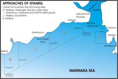
B) ISTANBUL STRAITS SOUTHERN ENTRANCE ANCHORAGE AREAS
A- Waiting anchorage area (for berthing to Istanbul ports)
1. 41ø 00'.40N, 28ø 59'.15E
2. 40ø 59'.39N, 28ø 58'.60E
3. 40ø 58'.15N, 28ø 56'.50E
4. 41ø 00'.15N, 28ø 56'.50E
B- Anchorage area for left Istanbul ports (waiting long period and supplying)
1. 41ø 00'.15N, 28ø 56'.50E
2. 40ø 58'.15N, 28ø 56'.50E
3. 40ø 56'.82N, 28ø 53'.50E
4. 40ø 58'.92N, 28ø 53'.50E
C- Anchorage area for dangerous cargo vessels
1. 40ø 58'.92N, 28ø 53'.50E
2. 40ø 56'.82N, 28ø 53'.50E
3. 40ø 56'.12N, 28ø 51'.95E
4. 40ø 55'.88N, 28ø 50'.00E
5. 40ø 57'.48N, 28ø 50'.00E
D- Anchorage areas for Quarantine control
1. 40ø 57'.54N, 28ø 48'.70E
2. 40ø 56'.10N, 28ø 48'.70E
3. 40ø 56'.40N, 28ø 47'.40E
4. 40ø 58'.23N, 28ø 47'.40E
E- Anchorage area at Kucukcekmece
1. 40ø 58'.32N, 28ø 43'.50E
2. 40ø 56'.90N, 28ø 43'.50E
3. 40ø 56'.40N, 28ø 47'.40E
4. 40ø 58'.23N, 28ø 47'.40E
F- Anchorage areas at Kartal
1. 40ø 53'.20N, 29ø 11'.10E
2. 40ø 52'.55N, 29ø 09'.55E
3. 40ø 51'.00N, 29ø 10'.30E
4. 40ø 51'.40N, 29ø 12'.00E
5. 40ø 52'.60N, 29ø 13'.40E.
Click for enlarge picture
C) CANAKKALE STRAITS NORTHERN ENTRANCE ANCHORAGE AREAS. (following coordinates)
A- Anchorage area for dangerous cargo vessels
1. 40ø 37'.55N, 27ø 10'.00E
2. 40ø 36'.45N, 27ø 10'.00E
3. 40ø 32'.65N, 27ø 00'.00E
4. 40ø 33'.42N, 26ø 59'.80E
B- Anchorage area for passenger and general cargo vessels
1. 40ø 33'.42N, 26ø 59'.80E
2. 40ø 32'.65N, 27ø 00'.00E
3. 40ø 30'.00N, 26ø 53'.00E
4. 40ø 31'.30N, 26ø 52'.40E
D) CANAKKALE STRAITS KARANLIK LIMAN ANCHORAGE AREA. (also quarantine control)
Pilotage is compulsory for areas
1. 40ø 00'.90N, 26ø 15'.10E
2. 40ø 01'.70N, 26ø 17'.40E
3. 40ø 03'.07N, 26ø 18'.95E
4. 40ø 02'.55N, 26ø 19'.80E
5. 40ø 01'.40N, 26ø 18'.75E
6. 40ø 00'.30N, 26ø 15'.20E
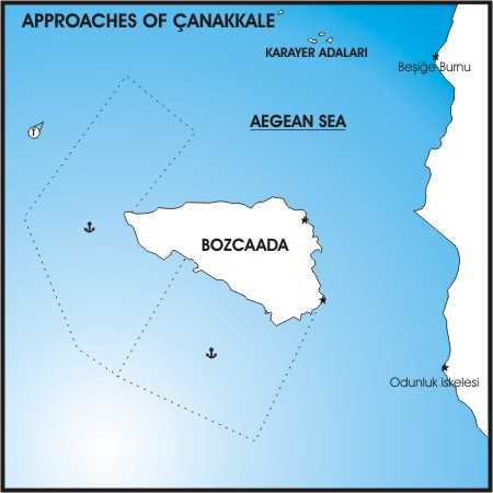
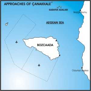
E) CANAKKALE STRAITS SOUTHERN ENTRANCE ANCHORAGE AREAS.
A- Anchorage area for dangerous cargo vessels
1. 39ø 49'.17N, 26ø 00'.00E
2. 39ø 46'.00N, 25ø 57'.40E
3. 39ø 46'.90N, 25ø 55'.30E
4. 39ø 50'.45N, 25ø 53'.40E
5. 39ø 54'.15N, 25ø 57'.80E
6. 39ø 52'.75N, 26ø 00'.00E
7. 39ø 50'.40N, 25ø 57'.90E
B- Anchorage area for passenger and general cargo vessels
1. 39ø 48'.10N, 26ø 04'.97E
2. 39ø 44'.00N, 26ø 01'.90E
3. 39ø 46'.00N, 25ø 57'.40E
4. 39ø 49'.17N, 26ø 00'.00E
Anchor of all vessels must be placed well within the anchorage areas, so that no portion of the hull or rigging
shall any time extend outside the boundaries of the anchorage area. No vessel shall anchor within a distance less
than 2,5 cables from the shore line.
Please contact before anchor with Traffic Control Center by VHF ch16 or 11 .
|