|
|
|


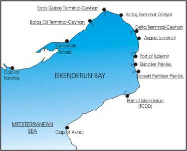
ISKENDERUN BAY. 36 37' N 036 07' E
Iskenderun Bay is located on the North-East end of the Eastern Mediterranean, accommodating governmental and private
berths and installations. Due to their geographical proximity, these facilities include oil terminals and dry cargo
ports, also serving as gateways to the Middle Eastern countries. A number of these ports and jetties were built
to serve specific purposes, such as importing minerals, ores, fertilizers, and scrap and exporting iron and steel
oil exports piped from Iraq and probably from Middle Asia in the near future. Iskenderun bay is now busy commercial
centers and an important ports of Turkey.
FORECAST: port officials at Iskenderun state that there are two weather scenarios that pose the greatest threat
to operations at the port.
The first, and most hazardous, is a southeasterly wind locally called "Yarikkaya". The winds funnel though
the valley that intersects the Nur Mountains southeast of the port. The southeast winds occasionally reach 64 kt
or greater. During an average year, the wind will occur about seven times during the September to April period.
The effect of the strong wind is to cause ships in the anchorage to drag anchor and, in some cases, even part the
anchor chain. Ships in the inner harbor must be carefully secured during such events, using tugs if necessary to
keep ships at their berths. It is suggested that ships in the anchorage move southwestward about 10 nmi to a location
away from the funneling and better sheltered from the strong southeasterly winds. Areas closer to shore offer better
protection than those farther out. Small boating is usually canceled during Yorikkaya events. The southeasterly
winds also affect the NATO fuel pier located about 3.5 nmi north of the main port. During one event, a ship securely
moored to the pier was in danger of pulling the pier down as the ship was forced away from its moorings. Two tugs
were required to restrain the ship before it was feasible to move it to a safe anchorage.
The second most trouble some phenomenon is a northerly wind which can reach 40 to 50 kt, and be accompanied by
6.5 to 10 ft swell at the anchorage. The effect is also felt at pier 1, because it is exposed to northerly winds
and waves that pass through the harbor entrance. Ships moored to pier 1 are moved in order to avoid potential damage
resulting from being forced onto the pier. According to port authorities, shelter from the northerly winds can
be found across the bay about 5 nmi east of Yumurtalik.
Forecasts of these and other meteorological events are broadcast in Turkish on VHF channels 16 and 67 and updated
every three hours. . (You can receive the broadcast in English on VHF if you required)

Click for enlarge picture
PILOTAGE : is compulsory for vessels entering or leaving the ports. , Call Pilots on VHF channels 16, or
their self channels three hours before arrival at the ports.
There are four pilot stations at Iskenderun bay.
a) (Sanmar) Toros Pilot for Toros Gubre, Delta Terminal and LPG terminals. ( pilot embarkation place 1,5 miles
south from end of the jetty)
b) Dekas Pilot for Ekinciler, Sariseki, Yazicilar and Isdemir. ( pilot embarkation place 1,5 miles south from end
of the jetty)
c) Iskenderun Pilot for Iskenderun TCDD port and Sasa terminal (Turkish State railways)
d) Botas Pilot for Dortyol Botas Terminal (pilot embarkation place 2 miles south from end of the jetty in the anchorage
zone)
a) (SANMAR) TOROS PILOT STATION:
Call Name : TOROS Pilot
Telephone : (90-326) 613 50 01 -4
Fax : (90-326) 634 23 23
VHF Band : Ch. 16, 12
Working Hours : 24 hours
b) ISKENDERUN DEKAS PILOT STATION:
Call Name : DEKAS Pilot
Telephone : (90- 326) 613 19 72
Fax : (90- 326) 613 19 74
VHF Band : Ch. 16, 14
Working Hours : 24 hours
c) ISKENDERUN TCDD PILOT STATION:
Call Name : ISKENDERUN Pilot
Telephone : (90-326) 614 00 47
Fax : (90-326) 613 24 24
VHF Band : Ch. 16, 13
Working Hours : 24 hours
d) ISKENDERUN (DORTYOL) BOTAS PILOT STATION:
Call Name : BOTAS Pilot
Telephone : (90-326) 613 58 59
Fax : (90-326) 613 16 57
VHF Band : Ch. 16, 22
Working Hours : 24 hours
TOWAGE: is provided by the Medmarine , TCDD, Sanmar, Isdemir & Botas and mooring boat arranged by pilot.
ISKENDERUN BAY ANCHORAGE AREAS; (Information on best location of anchorage will be given by Pilot station)
PILOT LADDER: will be prepared on vessel's starboard side. If your vessel's freeboard exceeds more than
5 meters, please prepare a combination ladder.
|
|
 |
history
 offices
 services

quality and insurance certificates
 lines represented
 group of companies
 ports ports
 news
news
 line schedule
 home
home
 contact us

|
|